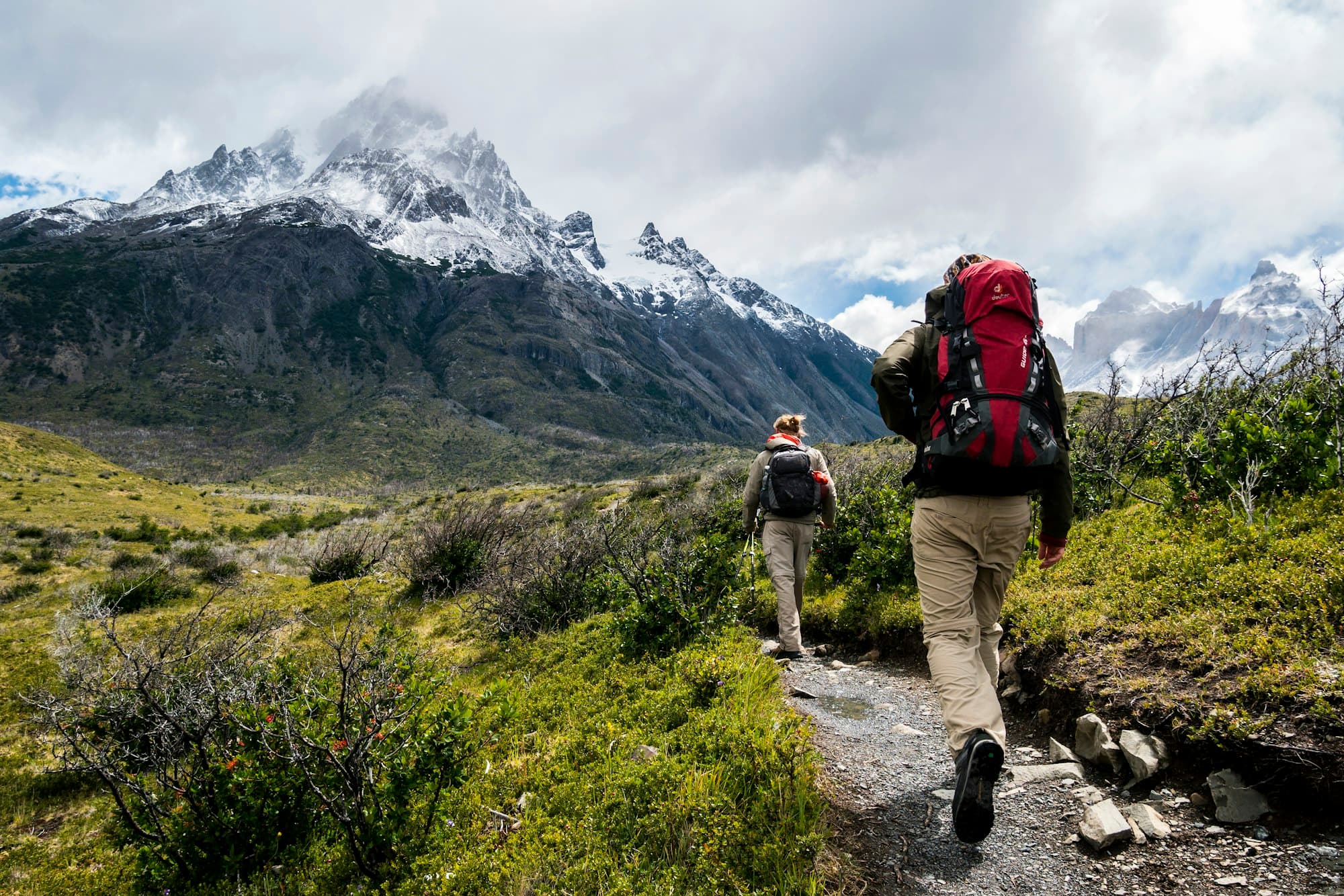
Clicky

Best Hikes Near Denver – 2025 Colorado Trail Guide

Best Hikes Near Denver

Your complete 2025 trail guide — from easy foothill walks to challenging alpine adventures in Colorado's stunning Front Range

Denver sits at the doorstep of some of America's most spectacular hiking terrain. Within an hour's drive, you can explore red rock canyons, alpine lakes, towering 14,000-foot peaks, and everything in between. The Front Range offers trails for every skill level—from gentle riverside walks perfect for families to challenging scrambles that test even experienced mountaineers.

What makes Denver hiking special isn't just the scenery—it's the accessibility. Unlike many mountain destinations where you need days to reach trailheads, Denver's best hikes are remarkably close. You can finish work, drive 30 minutes, and watch the sunset from a mountain summit. This proximity means you can explore different trails every weekend without repeating routes for months.

Whether you're planning a quick morning hike or a full-day alpine adventure, this guide covers everything you need to know. We'll walk you through the best trails organized by difficulty, share insider tips on timing and parking, and help you plan safe, memorable hikes in Colorado's stunning Front Range. For more Denver activities beyond hiking, check out our comprehensive guide to things to do in Denver.

Quick Trail Finder

  • 🥾 Easy: Red Rocks, Clear Creek, Mount Falcon
  • ⛰️ Moderate: St. Mary's Glacier, Royal Arch, Eldorado Canyon
  • 🏔️ Challenging: Mount Bierstadt, Sky Pond, Herman Gulch
  • 📸 Photography: Lost Lake, Dream Lake, Lookout Mountain

Denver Hiking Overview — What to Expect

Hiking near Denver means navigating unique terrain and conditions that differ significantly from sea-level trails. Understanding these characteristics helps you prepare properly and enjoy your hikes safely.

Terrain Types You'll Encounter

Front Range trails feature diverse landscapes. Lower-elevation hikes (5,000-7,000 feet) wind through red rock formations, ponderosa pine forests, and scrubland. Mid-elevation trails (7,000-10,000 feet) offer mixed conifer forests, aspen groves, and mountain meadows. High-altitude routes (10,000+ feet) enter alpine tundra with exposed ridges, snowfields, and dramatic rocky terrain.

Easy Trails

1-3 miles, <500 ft gain

Well-maintained paths, minimal scrambling, family-friendly

Moderate Trails

3-6 miles, 500-1,500 ft gain

Some steep sections, rocky terrain, good fitness required

Challenging Trails

6+ miles, 1,500+ ft gain

Steep climbs, scrambling, high altitude, experience needed

Seasonal Considerations

Colorado's hiking season varies dramatically by elevation. Lower trails near Morrison and Golden are accessible year-round, though winter ice may require traction devices. High-altitude trails typically open in late June and close by October due to snow. Summer brings afternoon thunderstorms—plan to summit by noon and descend before storms develop.

Altitude Awareness

Denver sits at 5,280 feet, but many trails reach 10,000-14,000 feet. Altitude sickness affects even fit hikers. Drink 2-3x more water than usual, start with lower-elevation trails, and allow your body time to acclimatize before attempting high-altitude hikes.

Trail Etiquette Essentials

  • Yield to uphill hikers (they're working harder)
  • Stay on marked trails to prevent erosion
  • Pack out all trash, including organic waste
  • Keep dogs leashed and pick up waste
  • Give wildlife plenty of space (minimum 25 yards)
  • Be courteous at popular photo spots

Best Easy Hikes Near Denver

These beginner-friendly trails offer stunning scenery without demanding technical skills or extreme fitness. Perfect for families, first-time hikers, or anyone wanting a relaxing outdoor experience close to Denver.

Red Rocks Trading Post Loop

Distance: 1.4 miles loop
Elevation Gain: 200 feet
Time: 45-60 minutes
Location: Morrison (20 miles SW)

This short loop showcases the iconic red rock formations that make Morrison famous. The well-maintained trail circles through towering sandstone fins with minimal elevation change, making it accessible for all ages. Morning light creates spectacular photography opportunities as the sun illuminates the red rocks against blue Colorado skies.

Insider Tips: Arrive early (before 9 AM) to avoid crowds and secure parking. The trail connects to Red Rocks Amphitheatre, where you can explore the venue and enjoy panoramic views of Denver. Combine this hike with breakfast in Morrison for a perfect morning outing.

Mount Falcon Castle Trail

Distance: 3.8 miles round trip
Elevation Gain: 650 feet
Time: 2-2.5 hours
Location: Morrison (20 miles W)

Mount Falcon offers one of the best views-to-effort ratios near Denver. The gradual climb through ponderosa pine forests leads to the ruins of John Brisben Walker's summer home, destroyed by fire in 1918. From the castle ruins, you'll enjoy 360-degree views spanning from downtown Denver to the Continental Divide.

Insider Tips: This trail is excellent for sunset hikes—watch the alpenglow paint the mountains pink and gold. The east-facing viewpoint provides stunning sunrise opportunities over Denver. Use our Distance Calculator to plan your drive time from Denver.

Clear Creek Trail

Distance: 2-10 miles (out-and-back)
Elevation Gain: Minimal (50 ft/mile)
Time: 1-4 hours
Location: Golden (15 miles W)

Following Clear Creek through Golden, this paved and gravel trail offers the easiest hiking near Denver. The flat, riverside path is perfect for families with young children, seniors, or anyone wanting a gentle walk in nature. The trail extends for miles, allowing you to customize your distance based on time and energy.

Insider Tips: The trail is accessible year-round and popular with cyclists—stay to the right and be aware of bike traffic. Stop at Golden City Brewery or Woody's Wood-Fired Pizza after your hike. The trail connects to downtown Golden, making it easy to combine hiking with shopping and dining.

Red Rocks Trading Post Loop trail winding through iconic red sandstone formations
Red Rocks Trading Post Loop offers stunning formations with minimal effort

Best Moderate Hikes Near Denver

These intermediate trails require good fitness and proper preparation but reward hikers with spectacular alpine scenery, unique geological features, and memorable summit views.

St. Mary's Glacier

Distance: 1.5 miles round trip
Elevation Gain: 700 feet
Time: 1.5-2 hours
Location: Idaho Springs (45 miles W)

Despite its short distance, St. Mary's Glacier packs serious elevation gain into a steep, rocky climb. The trail leads to a permanent snowfield and pristine alpine lake surrounded by 12,000-foot peaks. This hike offers a taste of high-altitude hiking without the commitment of a full 14er.

Insider Tips: The parking lot fills by 8 AM on summer weekends—arrive early or visit on weekdays. The "glacier" is technically a permanent snowfield, but it's still impressive. Bring layers; temperatures at 10,400 feet can be 20-30 degrees cooler than Denver. The snowfield is hikeable year-round but requires caution in winter.

Royal Arch Trail

Distance: 3.4 miles round trip
Elevation Gain: 1,000 feet
Time: 2-3 hours
Location: Boulder (30 miles NW)

Boulder's Royal Arch Trail climbs steeply through pine forests to a stunning natural sandstone arch perched high above the city. The final approach involves some scrambling over rocks, but the payoff is worth it—the arch frames perfect views of Boulder and the plains beyond.

Insider Tips: The steep, rocky sections can be challenging for beginners—take your time and use trekking poles if available. Morning hikes avoid afternoon heat and crowds. The arch itself is large enough to walk through, creating fantastic photo opportunities. Combine this hike with exploring Boulder's Pearl Street Mall.

Flatirons First/Second Flatiron Loop

Distance: 2.6 miles loop
Elevation Gain: 1,400 feet
Time: 2-2.5 hours
Location: Boulder (30 miles NW)

This classic Boulder hike takes you up close to the iconic Flatirons—massive tilted rock formations that define Boulder's skyline. The trail climbs steeply through meadows and forests, offering constantly changing perspectives of these geological wonders and sweeping views of Boulder Valley.

Insider Tips: The trail is extremely popular—weekday mornings offer the best experience. Bring plenty of water; there's no shade on much of the route. The steep descent can be hard on knees—trekking poles help significantly. Watch for rock climbers on the Flatirons themselves.

Eldorado Canyon Trail

Distance: 3.5 miles round trip
Elevation Gain: 850 feet
Time: 2-2.5 hours
Location: Eldorado Springs (35 miles W)

Eldorado Canyon State Park offers some of Colorado's most dramatic scenery. Towering canyon walls rise 800 feet above South Boulder Creek, creating a spectacular setting for hiking and rock climbing. The Rattlesnake Gulch Trail climbs to the ruins of the Crags Hotel, offering panoramic canyon views.

Insider Tips: The park charges a $10 entrance fee. Fall colors here are spectacular—aspens turn golden against red canyon walls. Watch for rock climbers on the canyon walls; Eldorado is world-famous for climbing. The trail can be hot in summer—bring extra water and start early.

St. Mary's Glacier trail leading to alpine lake and permanent snowfield
St. Mary's Glacier offers high-altitude scenery with a short but steep climb

Challenging & Adventurous Hikes

These demanding trails require excellent fitness, proper gear, and mountain experience. They reward prepared hikers with unforgettable alpine experiences and summit achievements.

Mount Bierstadt

Distance: 7 miles round trip
Elevation Gain: 2,850 feet
Time: 5-7 hours
Location: Guanella Pass (60 miles W)

Mount Bierstadt (14,065 feet) is Colorado's most accessible 14er and a popular first fourteener for many hikers. The well-maintained trail climbs through alpine tundra to a broad summit with 360-degree views of the Continental Divide. Despite being "easy" for a 14er, this is still a serious high-altitude hike requiring proper preparation.

Insider Tips: Start before sunrise (4-5 AM) to summit by noon and descend before afternoon thunderstorms. The trailhead sits at 11,600 feet—spend a day or two at altitude before attempting this hike. Bring warm layers; summit temperatures can be 30-40 degrees colder than Denver. The willows section can be boggy—waterproof boots help. Use our Time Calculator to plan your early departure from Denver.

Sky Pond via Glacier Gorge

Distance: 9 miles round trip
Elevation Gain: 1,750 feet
Time: 6-8 hours
Location: Rocky Mountain NP (70 miles NW)

Sky Pond is Rocky Mountain National Park's crown jewel—a pristine alpine lake surrounded by dramatic cliff faces and waterfalls. The trail passes Alberta Falls, The Loch, and Timberline Falls before reaching Sky Pond. The final approach involves scrambling up rocks beside a waterfall, adding adventure to the already spectacular scenery.

Insider Tips: RMNP requires timed-entry permits in summer (May-October)—reserve at recreation.gov weeks in advance. The waterfall scramble can be intimidating; take your time and use handholds carefully. This trail is best June-September; snow and ice make it dangerous outside this window. Bring bear spray and make noise in forested sections.

Herman Gulch

Distance: 6 miles round trip
Elevation Gain: 1,800 feet
Time: 4-5 hours
Location: Loveland Pass (55 miles W)

Herman Gulch offers one of Colorado's best wildflower displays in July and August. The trail climbs through a glacial valley carpeted with alpine flowers, leading to a high saddle with views of the Continental Divide. This hike showcases Colorado's alpine beauty without requiring a summit push.

Insider Tips: Peak wildflower season is mid-July through early August—the meadows explode with color. The trail is above treeline for most of its length; turn back immediately if thunderstorms approach. Parking is limited; arrive before 7 AM on summer weekends. The high elevation (starting at 10,300 feet) affects many hikers—pace yourself.

Mount Bierstadt summit with hikers enjoying panoramic Continental Divide views
Mount Bierstadt summit offers incredible 360-degree views at 14,065 feet

Scenic & Photography-Friendly Trails

These trails offer exceptional photography opportunities, from alpine lakes to mountain vistas. Bring your camera and plan for golden hour lighting to capture Colorado's stunning landscapes.

Lost Lake (Nederland)

Distance: 1 mile round trip
Elevation Gain: 200 feet
Time: 30-45 minutes
Location: Nederland (40 miles W)

This short, easy trail leads to a picturesque alpine lake surrounded by pine forests and rocky peaks. The lake's calm waters create perfect reflections of the surrounding mountains, making it a photographer's paradise. Despite its accessibility, Lost Lake feels remote and peaceful.

Photography Tips: Sunrise offers the best light and calmest water for reflections. Bring a wide-angle lens to capture the full scene. The trail is accessible most of the year, though winter requires snowshoes or microspikes.

Dream Lake & Emerald Lake (RMNP)

Distance: 3.6 miles round trip (Emerald)
Elevation Gain: 650 feet
Time: 2.5-3 hours
Location: Rocky Mountain NP (70 miles NW)

These iconic RMNP lakes showcase Colorado's alpine beauty at its finest. Dream Lake sits beneath Hallett Peak's dramatic face, while Emerald Lake nestles in a glacial cirque surrounded by towering cliffs. Both lakes offer stunning reflections and world-class mountain scenery.

Photography Tips: Arrive before sunrise to capture alpenglow on the peaks and avoid crowds. Bring a polarizing filter to enhance reflections and reduce glare. Fall offers golden aspens along the lower trail. Remember RMNP's timed-entry requirements.

Lookout Mountain Trails

Distance: 2-4 miles (various loops)
Elevation Gain: 400-800 feet
Time: 1.5-3 hours
Location: Golden (15 miles W)

Lookout Mountain offers some of the best Front Range views accessible by short hikes. Multiple trails wind through the area, all offering panoramic vistas of Denver, the plains, and the Continental Divide. The proximity to Buffalo Bill's grave adds historical interest.

Photography Tips: Sunset is magical here—watch the city lights begin to twinkle as the mountains fade to silhouette. Bring a telephoto lens to compress the layers of mountains. The area is accessible year-round and particularly beautiful after fresh snow.

Composition Tips for Mountain Photography

  • • Use foreground elements (rocks, flowers, trees) to add depth
  • • Shoot during golden hour (first/last hour of sunlight)
  • • Include people for scale in landscape shots
  • • Bring a tripod for long exposures and sharp images
  • • Use a polarizing filter to enhance skies and reduce glare

Best Time to Hike Near Denver

Colorado's hiking season varies dramatically by elevation and exposure. Understanding seasonal conditions helps you choose appropriate trails and prepare for changing weather.

Summer (June-August)

Summer opens access to high-altitude trails as snowpack melts. This is peak hiking season, with warm temperatures and long daylight hours. However, afternoon thunderstorms develop almost daily above treeline—plan to summit by noon and descend before storms arrive.

Best For: High-altitude hikes, 14ers, alpine lakes, wildflowers (July-August). Start early (5-6 AM) for popular trails and to avoid afternoon storms.

Fall (September-November)

Fall offers Colorado's best hiking conditions. Temperatures are comfortable, afternoon storms decrease, and aspen trees turn brilliant gold. Crowds thin after Labor Day, making popular trails more enjoyable. Early fall (September-early October) is ideal; late fall brings snow to high elevations.

Best For: All trails, fall colors, comfortable temperatures, fewer crowds. Peak aspen season is late September through early October.

Spring (April-May)

Spring is transitional—lower-elevation trails emerge from winter while high-altitude routes remain snow-covered. Foothill trails around Morrison, Golden, and Boulder are excellent, but mountain passes and alpine trails are inaccessible. Afternoon temperatures can swing 30+ degrees.

Best For: Lower-elevation trails, wildflowers (May), avoiding crowds. Stick to trails below 8,000 feet until June.

Winter (December-March)

Winter hiking requires specialized gear and knowledge. Lower-elevation trails remain accessible with microspikes or snowshoes, but high-altitude routes are dangerous without mountaineering experience. Snow-covered trails offer solitude and beauty but demand respect for winter conditions.

Best For: Lower-elevation trails, solitude, winter scenery. Bring microspikes, extra layers, and check avalanche conditions. Stick to well-traveled routes.

Fall hiking trail with golden aspens and mountain backdrop
Fall offers ideal hiking conditions with golden aspens and comfortable temperatures

Altitude & Weather Awareness

Colorado weather changes rapidly, especially at altitude. Always check forecasts before hiking and be prepared to turn back if conditions deteriorate. For safety information, visit our travel safety guide.

How to Plan Your Hiking Trip

Successful hiking trips require more than just showing up at a trailhead. Smart planning ensures you have time to enjoy the trail without rushing and helps you avoid common pitfalls that derail hiking days.

Calculate Realistic Timing

Don't underestimate total trip time. Factor in driving to the trailhead, parking challenges, the hike itself, breaks, and the drive home. Use our Time Calculator to estimate driving time from Denver to trailheads, then add hiking time based on your pace.

Sample Day Trip Timeline

5:00 AM - Leave DenverEarly start
6:30 AM - Arrive at trailhead1.5 hour drive
7:00 AM - Start hikingGear up, bathroom
11:00 AM - Reach summit4 hours up
11:30 AM - Begin descentLunch, photos
2:00 PM - Return to car2.5 hours down
4:00 PM - Back in DenverDrive + stops

Parking & Access Considerations

Popular trailheads fill early, especially on summer weekends. Many require parking passes or have limited spaces. Research parking requirements before you go and have backup plans if lots are full.

  • Red Rocks/Morrison: Free parking, but fills by 9 AM weekends
  • Rocky Mountain NP: Timed-entry permits required (reserve at recreation.gov)
  • Eldorado Canyon: $10 entrance fee, limited parking
  • Mount Bierstadt: Free but extremely limited; arrive before 6 AM
  • Boulder Trails: Various parking fees and time limits

Use Planning Tools Effectively

Our suite of calculators helps you plan every aspect of your hiking trip:

Distance & Time

Budget & Logistics

Sample Itineraries

1-Day Beginner Itinerary

Morning: Red Rocks Trading Post Loop (1.5 hours) → Breakfast in Morrison
Afternoon: Mount Falcon Castle Trail (2.5 hours) → Sunset at Red Rocks Amphitheatre

1-Day Intermediate Itinerary

Early Start: St. Mary's Glacier (3 hours total) → Lunch in Idaho Springs
Afternoon: Explore Georgetown or relax at hot springs

Weekend Advanced Itinerary

Day 1: Mount Bierstadt (full day) → Stay in Georgetown
Day 2: Herman Gulch wildflowers (half day) → Return to Denver

What to Pack for Denver-Area Hikes

Colorado's variable weather and high altitude demand specific gear. Proper packing makes the difference between an enjoyable hike and a miserable experience.

The Ten Essentials

These items should accompany you on every hike, regardless of difficulty or duration:

Always Bring

  • ✓ Navigation (phone app + backup map)
  • ✓ Sun protection (sunscreen SPF 30+, hat, sunglasses)
  • ✓ Insulation (extra layers, rain jacket)
  • ✓ Illumination (headlamp with extra batteries)
  • ✓ First-aid supplies
  • ✓ Fire starter (matches/lighter)
  • ✓ Repair kit (duct tape, knife)
  • ✓ Nutrition (extra food)
  • ✓ Hydration (2-3 liters per person)
  • ✓ Emergency shelter (space blanket)

Recommended Additions

  • • Trekking poles (reduce knee strain)
  • • Camera/phone for photos
  • • Portable charger
  • • Whistle (emergency signaling)
  • • Toilet paper + trowel
  • • Insect repellent (summer)
  • • Bear spray (RMNP, wilderness areas)
  • • Microspikes (winter/early spring)
  • • Gaiters (snow, mud protection)
  • • Satellite communicator (remote trails)

Footwear Considerations

Proper footwear prevents blisters, provides ankle support, and improves traction on rocky terrain. For easy trails, trail runners work fine. Moderate and difficult hikes require hiking boots with ankle support and aggressive tread.

Break In Your Boots

Never wear brand-new boots on a long hike. Break them in with several shorter walks to prevent painful blisters. Bring moleskin or blister treatment just in case.

Layering for Colorado Weather

Colorado weather changes rapidly, especially at altitude. Temperatures can swing 30-40 degrees between morning and afternoon, and storms develop quickly. The layering system allows you to adjust as conditions change.

  • Base Layer: Moisture-wicking shirt (avoid cotton)
  • Mid Layer: Fleece or light puffy jacket for warmth
  • Outer Layer: Waterproof, windproof rain jacket
  • Bottom: Hiking pants or shorts + rain pants
  • Accessories: Hat, gloves, buff/neck gaiter

For complete packing guidance, check our travel packing list for additional tips.

Essential hiking gear including boots, backpack, layers, and safety equipment
Proper gear makes Colorado hiking safer and more enjoyable

Safety Tips for Hiking Near Denver

Colorado's mountains are beautiful but demand respect. Understanding and preparing for specific hazards keeps you safe while enjoying the trails.

High-Altitude Considerations

Altitude affects everyone differently, regardless of fitness level. Denver sits at 5,280 feet, but many trails reach 10,000-14,000 feet. The air contains 30-40% less oxygen at these elevations, making every activity more challenging.

Altitude Sickness Symptoms

  • • Headache, nausea, dizziness
  • • Fatigue and weakness
  • • Shortness of breath
  • • Loss of appetite
  • • Difficulty sleeping

If symptoms worsen, descend immediately. Altitude sickness can become life-threatening if ignored.

Prevention strategies: Drink 2-3x more water than usual, avoid alcohol the night before, start with lower-elevation hikes, ascend gradually, and listen to your body. Consider spending a day or two at altitude before attempting high-elevation hikes.

Sudden Weather Changes

Colorado weather is notoriously unpredictable. Summer afternoons bring thunderstorms with lightning, hail, and temperature drops. These storms develop quickly—clear skies can turn dangerous in 30 minutes.

Lightning Safety Rules

  • • Start early; summit by noon in summer
  • • Turn back if storms approach (dark clouds, thunder)
  • • Get below treeline immediately if caught in a storm
  • • Avoid isolated trees, peaks, and ridges
  • • Crouch low if caught in the open (don't lie flat)
  • • Wait 30 minutes after last thunder before continuing

Wildlife Awareness

Colorado is home to black bears, mountain lions, moose, elk, and rattlesnakes. Most wildlife avoids humans, but encounters happen. Knowing how to respond keeps both you and animals safe.

  • Bears: Make noise while hiking, store food properly, carry bear spray in wilderness areas. If encountered, back away slowly while facing the bear.
  • Mountain Lions: Rare but present. Don't run; make yourself large, maintain eye contact, fight back if attacked.
  • Moose: Give wide berth (25+ yards). More dangerous than bears when provoked, especially mothers with calves.
  • Rattlesnakes: Common on lower-elevation trails. Watch where you step, don't reach into crevices, give snakes space to retreat.

Hydration and Sun Protection

Colorado's high altitude and low humidity accelerate dehydration. The sun is 25% stronger at altitude, making sunburn happen faster. These factors combine to create serious health risks if ignored.

Hydration Guidelines

Drink before you feel thirsty—thirst indicates you're already dehydrated. Bring 2-3 liters per person for moderate hikes, more for long or strenuous routes. Add electrolyte tablets for hikes over 4 hours.

Sun Protection: Apply SPF 30+ sunscreen every 2 hours, wear a wide-brimmed hat, use sunglasses with UV protection, and cover exposed skin.

Staying on Marked Trails

Colorado's alpine environment is fragile. Shortcutting switchbacks and creating social trails causes erosion that takes decades to heal. Staying on marked paths protects the environment and keeps you safe from cliffs and unstable terrain.

For comprehensive safety information, visit our travel safety guide.

Emergency Contacts

  • Emergency: 911 (works on most trails with cell service)
  • Rocky Mountain NP: 970-586-1399
  • Colorado Search & Rescue: 911 or local sheriff
  • Weather Updates: weather.gov or Mountain-Forecast.com

Final Thoughts — Enjoy Colorado's Trails Responsibly

Denver's proximity to world-class hiking is one of Colorado's greatest gifts. Within an hour, you can stand on mountain summits, explore alpine lakes, and experience landscapes that rival anywhere on Earth. This accessibility is a privilege that comes with responsibility.

Every hiker plays a role in preserving these trails for future generations. Stay on marked paths, pack out all trash, respect wildlife, and help others when needed. The mountains will reward your respect with unforgettable experiences.

Your Hiking Checklist

  1. 1. Choose a trail matching your fitness and experience level
  2. 2. Check weather forecasts and trail conditions
  3. 3. Use our Trip Time Calculator to plan timing and routes
  4. 4. Pack the ten essentials plus extra water and layers
  5. 5. Start early to avoid crowds and afternoon storms
  6. 6. Tell someone your plans and expected return time
  7. 7. Respect altitude, weather, and wildlife
  8. 8. Leave no trace and stay on marked trails

Whether you're tackling your first 14er or enjoying a sunset stroll through red rocks, Colorado's trails offer something magical. With proper planning, appropriate gear, and respect for the mountains, you'll create memories that last a lifetime.

Looking for more Denver adventures beyond hiking? Explore our complete guide to things to do in Denver for breweries, museums, neighborhoods, and more.

Last Updated: January 2025

Frequently Asked Questions

Difficulty Levels

Easy
1-3 miles, <500 ft gain
Moderate
3-6 miles, 500-1,500 ft gain
Challenging
6+ miles, 1,500+ ft gain

Hiking Checklist

Check weather forecast
Pack 2-3 liters water
Bring layers & rain jacket
Apply sunscreen SPF 30+
Tell someone your plans
Start early (before 7 AM)
Pack first-aid kit
Hiker enjoying panoramic mountain views on Colorado trail

Start Your Adventure

Use our calculators to plan the perfect hiking day near Denver.