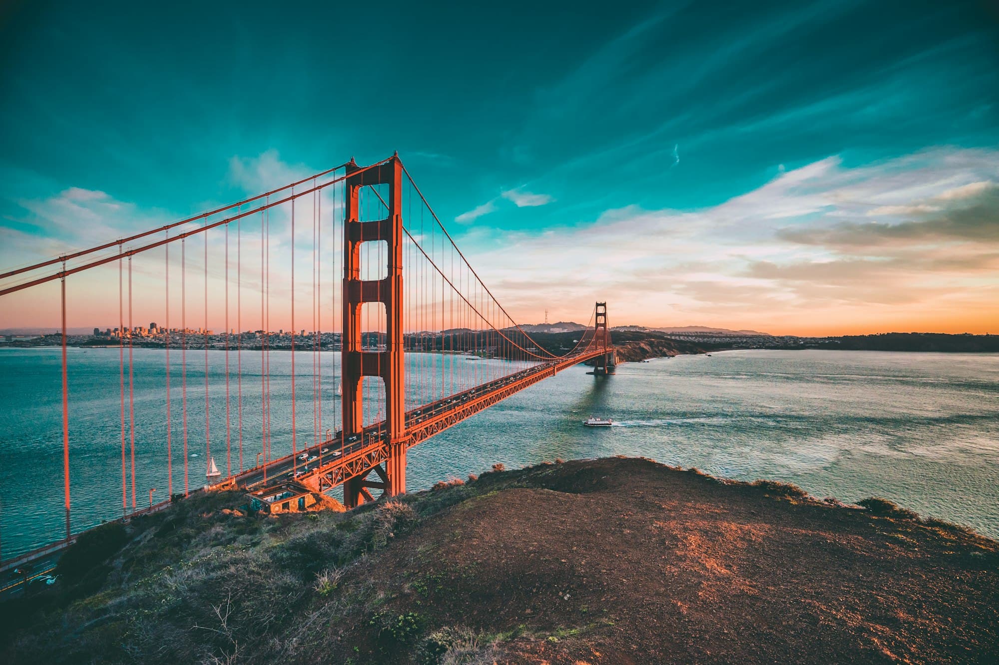
Pacific Coast Highway Road Trip Guide
Plan the ultimate California coastal adventure from San Francisco to San Diego along one of America's most scenic highways.
Quick Overview
655 miles (1,055 km)
5-7 days minimum
April-May, Sept-Oct
$150-400/day
The Pacific Coast Highway (Highway 1) is one of the most spectacular coastal drives in the world. This iconic route takes you along California's dramatic coastline, through charming beach towns, past rugged cliffs, and alongside pristine beaches.
This guide will help you plan the perfect PCH road trip using our planning tools, with detailed stops, budget breakdowns, and insider tips for an unforgettable journey.
Complete Route Breakdown
San Francisco
Duration: 1-2 days
Highlights: Golden Gate Bridge, Fisherman's Wharf, Alcatraz, Cable Cars, Chinatown
Pro Tip: Start your journey early morning to cross the Golden Gate Bridge with minimal traffic. Stop at Battery Spencer for the best bridge photos.
Half Moon Bay
Distance from SF: 30 miles (45 min)
Highlights: Mavericks surf spot, coastal trails, pumpkin farms, seafood restaurants
Pro Tip: Stop at Sam's Chowder House for award-winning clam chowder and ocean views.
Santa Cruz
Distance from Half Moon Bay: 45 miles (1 hour)
Highlights: Beach Boardwalk, Natural Bridges State Beach, surf culture, redwood forests
Pro Tip: Visit the historic Beach Boardwalk for classic amusement park fun and try the famous corn dogs.
Monterey & Carmel-by-the-Sea
Distance from Santa Cruz: 45 miles (1 hour)
Duration: 1-2 days
Highlights: Monterey Bay Aquarium, 17-Mile Drive, Carmel Beach, Cannery Row, Point Lobos
Pro Tip: The 17-Mile Drive costs $11.25 but is worth every penny. Go at sunset for magical lighting.
Big Sur
Distance from Carmel: 30 miles (1 hour)
Duration: 1-2 days
Highlights: Bixby Bridge, McWay Falls, Pfeiffer Beach, Julia Pfeiffer Burns State Park
Pro Tip: Book accommodations months in advance. Big Sur has limited lodging and fills up quickly. Check road conditions before going as Highway 1 occasionally closes due to landslides.
San Luis Obispo
Distance from Big Sur: 95 miles (2.5 hours)
Highlights: Bubblegum Alley, Mission San Luis Obispo, Thursday night farmers market, Hearst Castle nearby
Pro Tip: Take a detour to Hearst Castle (45 min north) for a glimpse of opulent 1920s luxury.
Santa Barbara
Distance from SLO: 100 miles (2 hours)
Duration: 1-2 days
Highlights: Spanish architecture, Stearns Wharf, wine country, beaches, State Street shopping
Pro Tip: Visit the Santa Barbara County Courthouse for free and climb the clock tower for panoramic city views.
Malibu
Distance from Santa Barbara: 80 miles (1.5 hours)
Highlights: Zuma Beach, Malibu Pier, El Matador Beach, celebrity homes, surf culture
Pro Tip: El Matador Beach requires a short hike down but offers stunning rock formations and caves perfect for photos.
Los Angeles
Distance from Malibu: 30 miles (45 min)
Duration: 2-3 days
Highlights: Santa Monica Pier, Venice Beach, Hollywood, Griffith Observatory, Getty Center
Pro Tip: LA traffic is notorious. Use public transit or plan activities by neighborhood to minimize driving.
Laguna Beach & Dana Point
Distance from LA: 55 miles (1 hour)
Highlights: Art galleries, tide pools, Crystal Cove State Park, scenic beaches
Pro Tip: Visit during low tide to explore the tide pools at Treasure Island Beach.
San Diego
Distance from Laguna Beach: 65 miles (1.5 hours)
Duration: 2-3 days
Highlights: Balboa Park, San Diego Zoo, Gaslamp Quarter, La Jolla Cove, Coronado Beach
Pro Tip: End your trip at La Jolla Cove to see sea lions and enjoy some of California's best snorkeling.
Complete Budget Breakdown
| Expense Category | Budget | Mid-Range | Luxury |
|---|---|---|---|
| Accommodation (per night) | $80-120 | $150-250 | $300-600+ |
| Food (per day) | $40-60 | $80-120 | $150-250+ |
| Car Rental (per day) | $40-60 | $70-100 | $120-200+ |
| Gas (total trip) | $100-150 | $100-150 | $100-150 |
| Activities & Attractions | $20-40/day | $50-80/day | $100-200+/day |
| Parking & Tolls | $10-20/day | $15-30/day | $20-50/day |
| TOTAL (per day) | $150-250 | $315-480 | $640-1,200+ |
| 7-DAY TRIP TOTAL | $1,050-1,750 | $2,205-3,360 | $4,480-8,400+ |
Money-Saving Tips
- • Travel in shoulder season (April-May, Sept-Oct) for lower accommodation prices
- • Book Big Sur lodging 3-6 months in advance for better rates
- • Pack snacks and picnic supplies to save on meals
- • Many beaches and viewpoints are free to visit
- • Consider camping in state parks ($35-50/night)
- • Fill up gas in cities rather than remote coastal areas
Best Time to Drive the PCH
Best Months
April-May & September-October
- • Mild temperatures (60-75°F)
- • Less fog than summer
- • Fewer crowds
- • Lower accommodation prices
- • Wildflowers in spring
Summer (June-August)
Pros & Cons
- ✓ Warmest weather
- ✓ Longest days
- ✗ Heavy fog on coast
- ✗ Peak crowds
- ✗ Highest prices
- ✗ Traffic congestion
Winter (Nov-March)
Pros & Cons
- ✓ Lowest prices
- ✓ Minimal crowds
- ✓ Whale watching season
- ✗ Rain and storms
- ✗ Possible road closures
- ✗ Shorter days
Avoid If Possible
Peak Summer Weekends
- • Memorial Day weekend
- • 4th of July weekend
- • Labor Day weekend
- • Extreme traffic
- • Fully booked hotels
- • 2-3x normal prices
Essential Tips for Your PCH Road Trip
Driving Tips
- • Drive north to south for ocean views on your side
- • Use pullouts frequently to let faster traffic pass
- • Fill up gas whenever you can - stations are sparse in Big Sur
- • Download offline maps as cell service is spotty
- • Check Caltrans for road closures before you go
- • Allow extra time - the drive takes longer than GPS estimates
Photography Tips
- • Golden hour (sunrise/sunset) offers the best lighting
- • Bixby Bridge is most photogenic from the north side
- • McWay Falls is best photographed from the overlook trail
- • Bring a polarizing filter to reduce glare on water
- • Fog can create dramatic photos but also obscure views
Food & Dining
- • Nepenthe in Big Sur - iconic restaurant with stunning views
- • Duarte's Tavern in Pescadero - famous artichoke soup
- • The Lark in Santa Barbara - farm-to-table dining
- • Malibu Farm on the pier - fresh, healthy California cuisine
- • Pack snacks and water - food options are limited in remote areas
Safety & Preparation
- • Bring layers - coastal weather changes quickly
- • Stay on marked trails near cliffs
- • Never turn your back on the ocean - rogue waves are dangerous
- • Carry a first aid kit and emergency supplies
- • Book accommodations in advance, especially in Big Sur
- • Have a backup plan if Highway 1 is closed
Sample 7-Day Itinerary
Day 1: San Francisco
Explore the city, cross Golden Gate Bridge, visit Fisherman's Wharf
Day 2: SF to Monterey/Carmel
Stop in Half Moon Bay and Santa Cruz, arrive in Monterey for sunset
Day 3: Monterey & 17-Mile Drive
Monterey Bay Aquarium, 17-Mile Drive, explore Carmel-by-the-Sea
Day 4: Big Sur
Bixby Bridge, McWay Falls, Pfeiffer Beach, stay overnight in Big Sur
Day 5: Big Sur to Santa Barbara
Morning in Big Sur, drive to Santa Barbara via San Luis Obispo
Day 6: Santa Barbara to LA
Explore Santa Barbara morning, stop in Malibu, arrive LA evening
Day 7: LA to San Diego
Morning in LA, drive through Orange County, end in San Diego
Common Mistakes to Avoid
Rushing the Drive
Don't try to do the entire route in 2-3 days. You'll miss the best parts and spend all your time driving.
Not Booking Big Sur
Big Sur has very limited lodging. Book 3-6 months ahead or you'll have to skip this highlight.
Ignoring Road Conditions
Highway 1 frequently closes due to landslides. Always check Caltrans before and during your trip.
Driving South to North
Drive north to south so the ocean is on your side, making it easier to pull over for views.
Underestimating Fog
Summer fog can obscure views for days. Spring and fall offer clearer conditions.
Not Bringing Layers
Coastal weather changes dramatically. Bring warm layers even in summer.
